Tampere, Budapest, Oulu
Byte-powered Future
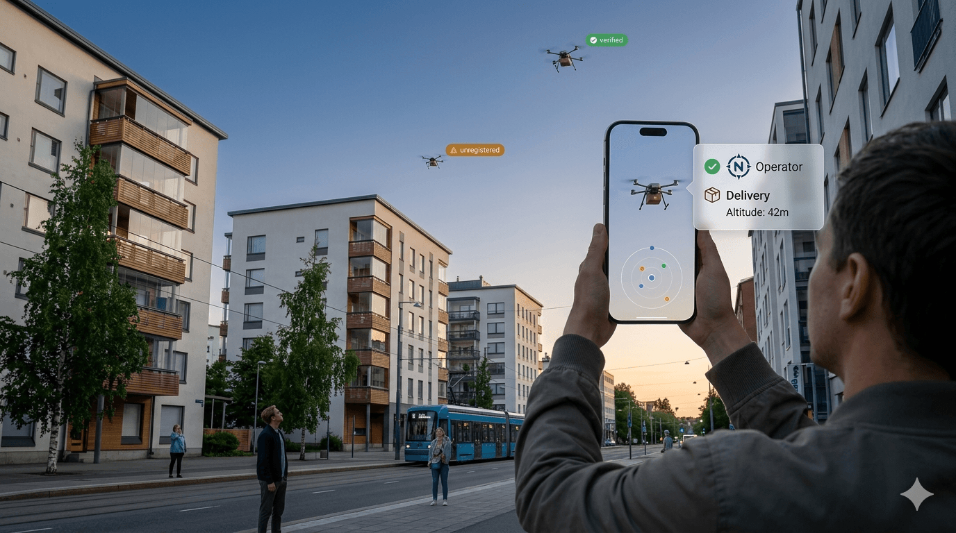
The skies above cities are filling up in the future. Delivery drones, inspection drones, media drones, security drones, recreational flyers, and research platforms now share low-altitude urban airspace that was effectively empty a decade ago. This growth is accelerating: logistics companies, infrastructure operators, emergency services, and defence-adjacent actors are all expanding drone operations in urban environments. Yet from street level, a drone overhead is essentially anonymous. There is no visible equivalent of a licence plate, no public registry lookup, no way for a citizen, business owner, or city official to know whether a drone flying over their building is on a permitted mission. Finland’s regulatory framework (EASA U-space, Traficom drone registry) provides the legal backbone — but none of this is accessible in real time to people on the ground. This project builds the missing transparency layer.
What is the right identification interaction: point your phone at a drone and get information (AR overlay), scan a visible QR or RF signal on the drone, or query by location and time? Which is technically feasible within a project sprint? How should flight purpose categories be communicated to citizens in a way that is informative without being alarmist — what is the right language and visual vocabulary for authorised commercial, recreational, media, inspection, security, and unknown/unregistered drones?
In the project we are looking to design an identification prototype — a functional mobile tool (web or app) that, given a GPS location and timestamp, identifies the drone and returns verified information about whose drone it is and what is it doing here.

COO
+358 50 529 1845
joonas@demola.net

Program Manager
+358 50 582 7401
heikku@demola.net

Head of Demola Budapest
+36209225778
laszlo@demola.net
.jpg&w=256&q=75)
Head of Startup Development
+358 45 233 3056
mirza@demola.net
Ongoing project
Apply by
26 Apr 2026
Location
Tampere
Teamwork
In person
Language
English
Project starts
04 May 2026
Independent work
04 May 2026 - 08 May 2026
Teamwork kick-off
11 May 2026
Final session
03 Jul 2026
Project ends
03 Jul 2026
##ar
##data
##drones
##transparency
#urban safety